Floor Plans

Business Case: Subway Mapping & Routing

Problem:

A transit authority was interested in standing up a routing solution for their subway system.  The system needed to route a user from the street to the train door.  They had stations that ranged in sizes and condition, all which they had very little documentation about.  They needed a solution that could solve the data collection and production challenge for their routing use case, as well as provide critical data to their maintenance and public safety departments.  They wanted accurate 2D plans that were geospatial and could connect into their street level data, as well as 3D asset data and 360 Imagery.     

Summary:

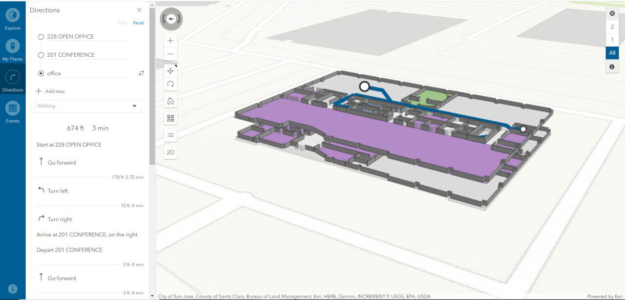
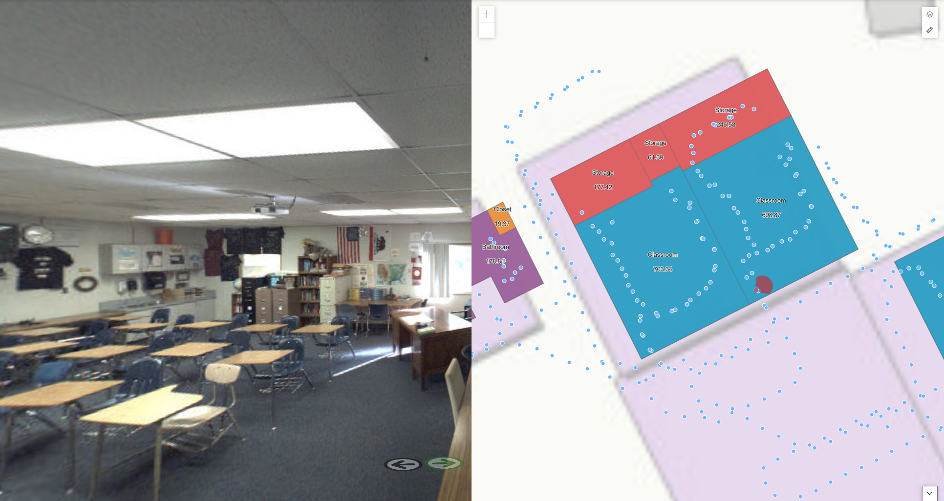
IndoorVu was able to rapidly collect data in all the stations.  The IndoorVu collection system allows maximum flexibility in variable indoor conditions.  After a single scan, IndoorVu was able to create geo-reference 2D plans and network routing data for the routing application that included multiple user types (ie: ADA, Non-ADA, Private, etc.).  It was also able to stand up 360 imagery and map data via IndoorVu Portal that was accessible for other use cases.  The data also integrated directly into the Transit Authority’s existing business systems: GIS, Work Order Management, Asset Management, Facilities Management and Capital Planning. 

IV Portal.  2D Floor Plans by level and 360 imagery

IV Portal. 2D Floor Plans by level and 360 imagery

Result:

The Transit Authority was able to procure all their data needs (collection, production, hosting and integration) from a single vendor.  They received consistent data across all their stations and seamlessly integrated the data into their existing systems.  They were quickly able to stand up a geo-referenced set of underground maps for all their stations that aligned and integrated with their street level data.

Business Case: Indoor Routing and Wayfinding in Government/Office

Problem:

County Government has 55 buildings spread across their region.  They want to update their building data, standup an indoor GIS and turn on an indoor routing solution for employees and visitors. They have little to no building models or plans that are digital or accurate.  

Summary:

IndoorVu deployed a team to the county and collected Intelligent Imagery for all the country buildings within 14 days.  Then rapidly created geo-referenced floor plans and 360 degree imagery.  That data was delivered via IndoorVu Portal and integrated directly into the County’s existing Esri ArcGIS infrastructure.  IndoorVu also configured the floor plans to import into the Esri ArcGIS Indoors system.  That configuration included modifying the floor plan data model as well as developing a network graph to drive user routing and wayfinding.  

routing.jpg

Result:

The County went from having very little digital data to having a completed digital geospatial system for all their building and assets in a matter of weeks.  They have integrated the floor plans and imagery into their existing GIS database, security, facilities management and maintenance systems.  They saved administrative time and expense by having a single vendor, IndoorVu, create and produce all the data they needed.  They also benefited from having the data seamlessly integrate with their existing systems.  The County now has a foundation for future asset details and digital modeling for all of their properties.  This reduces the amount of travel their staff must to do maintain the assets, as well as allows them to make data available to 3rd party organizations that can benefit from it.  

Business Case: Space Planning in Retail

Problem:

A retail bank company wanted to redesign their branches to optimize their layouts for employee experience and customer satisfaction.  They had hundreds of branch locations, but not all of them had good floor plan data.  They needed a scalable solution that could deploy all over the country and produce consistent results.  They also wanted to have flexibility in the level of detail they could extract on a branch by branch basis.  

Summary:

IndoorVu configured resources to collect data across all branch locations that needed data, approximately 50 sites across a dozen states in the US.  The teams spent just over an hour in each branch, hardley impacting the operations of the branch.  The Intelligent Imagery that was collected and produced enabled IndoorVu to quickly create complete 2D geo-referenced floor plans for all the buildings, plus 360 imagery to provide context and additional visual detail.  

IV Portal: Floor Plans, 360 Imagery

IV Portal: Floor Plans, 360 Imagery

Result:

The Bank’s space planning team was able to create a standardized process for assessing and redesigning their spaces.  The IndoorVu Portal was a single web-accessed application that the Bank’s teams could remotely access.  They were able to make rapid, educated decisions about the spaces and the level of effort to achieve the new designs. The Bank also now has a foundation for detailed 3 Dimensional mapping and modeling for future improvements and changes to the branches as they need. 

Business Case: Asset Inventory in Retail / Industrial

Problem:

A large retail occupier needed to update and improve their asset management system.  They had basic floor plans for all their sites, but lacked detail about the assets within them (ie: fire systems, hvac, lighting, electrical, plumbing, utilities).  They needed a scalable solution that could work across hundreds of sites and produce consistent data.  They also wanted to remove a number of manual steps from their current process both in collecting asset data as well as importing it into their current Enterprise Asset Management (EAM) system.   

Summary:

IndoorVu configured resources to collect data across hundreds of sites and multiple geographies.  IndoorVu teams spend less than a day in sites that are hundreds of thousands of square feet.  Then remotely can extract the precise 3 Dimensional information for all kinds of assets.  When the asset data is extracted from the imagery, it populates a pre-configured data model that matches the customers EAM system.  IndoorVu delivers all the data via the IndoorVu Portal, which visualizes all the assets, places them into the correct location on the floor plan and provides an editable interface to update and/or modify asset attributes. 

IV Portal.  Floor Plans, Asset Details, 360 Imagery

IV Portal. Floor Plans, Asset Details, 360 Imagery

Result:

The net result is that instead of taking months of expert’s time to visit each site and manually collect data in the field then again manually import that data into an EAM, the expert can now remotely access imagery for each site and extract the location and details of assets. The work gets done much faster and with less costs.  The retailer also has comprehensive imagery for all their sites and the ability to extract additional 3 Dimensional information about their buildings on an as needed basis.  

Business Case: Space Planning and Design in Education

Problem:

This school district was faced with the challenge of redesign their spaces to comply with new Covid-19 restrictions for student spaces.  Their challenge was that they had paper drawings for all their buildings.  They needed to update the drawings, ensure they were correct and scaled, integrate them into GIS tools to optimize the space layouts and enable virtual teams to collaborate on redesigning the spaces.   = 

Summary:

IndoorVu was rapidly collected data at 5 High Schools throughout the district.  From the IndoorVu Intelligent Imagery, geospatial floor plans were generated and enhanced with 360 degree imagery.  The data was loaded into the IndoorVu Portal, provided as CAD (dwg) files and as GIS (geodatabase) files.  

IndoorVu Portal.  2D Floor Plans, 360 Imagery

IndoorVu Portal. 2D Floor Plans, 360 Imagery

Result:

The School District was able to quickly stand up data and a standard workflow across all their High Schools to remotely reconfigure the spaces.  They were able to seamlessly integrate their data into their existing GIS and CAD software tools.  The 360 Imagery provided critical visual information about their spaces so that teams working from home could be effective.