Cellular Network Audit

Problem:

A large commercial, mixed use, building wanted to understand how well the different cellular operator networks were performing in their building.  They had a feeling that it wasn’t working that well, as they were getting complaints from tenants.  In the past they had a couple surveys done, but were not confident that enough of the spaces on each floor were tested to accurately represent the current performance.  They wanted to be sure, and they wanted to be able to show their tenants that they had invested in addressing the issues they were having.  They also wanted to know how bad it actually was, so they could assess the options they had to improve it.   

Summary:

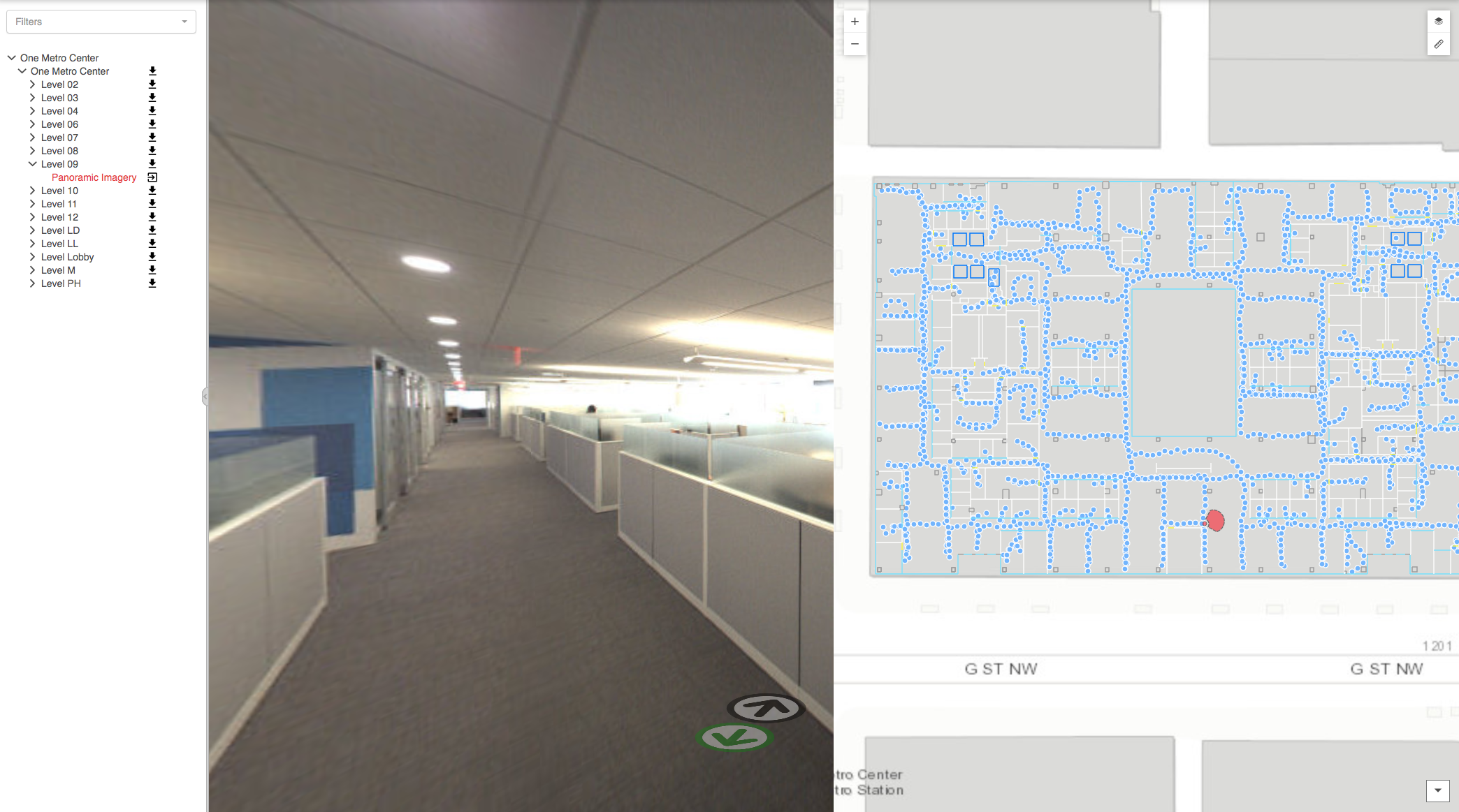
IndoorVu, with its proprietary indoor mapping technology and integrated cellular testing capability, was able to rapidly walk every room in the building and test all 4 (Verizon, AT&T, T-Mobile and Sprint) at the same time.  The images below compare a typical walk route with the IndoorVu walk route.  

Typical Walk Route                                                                    IndoorVu Walk Route

Typical Walk Route IndoorVu Walk Route

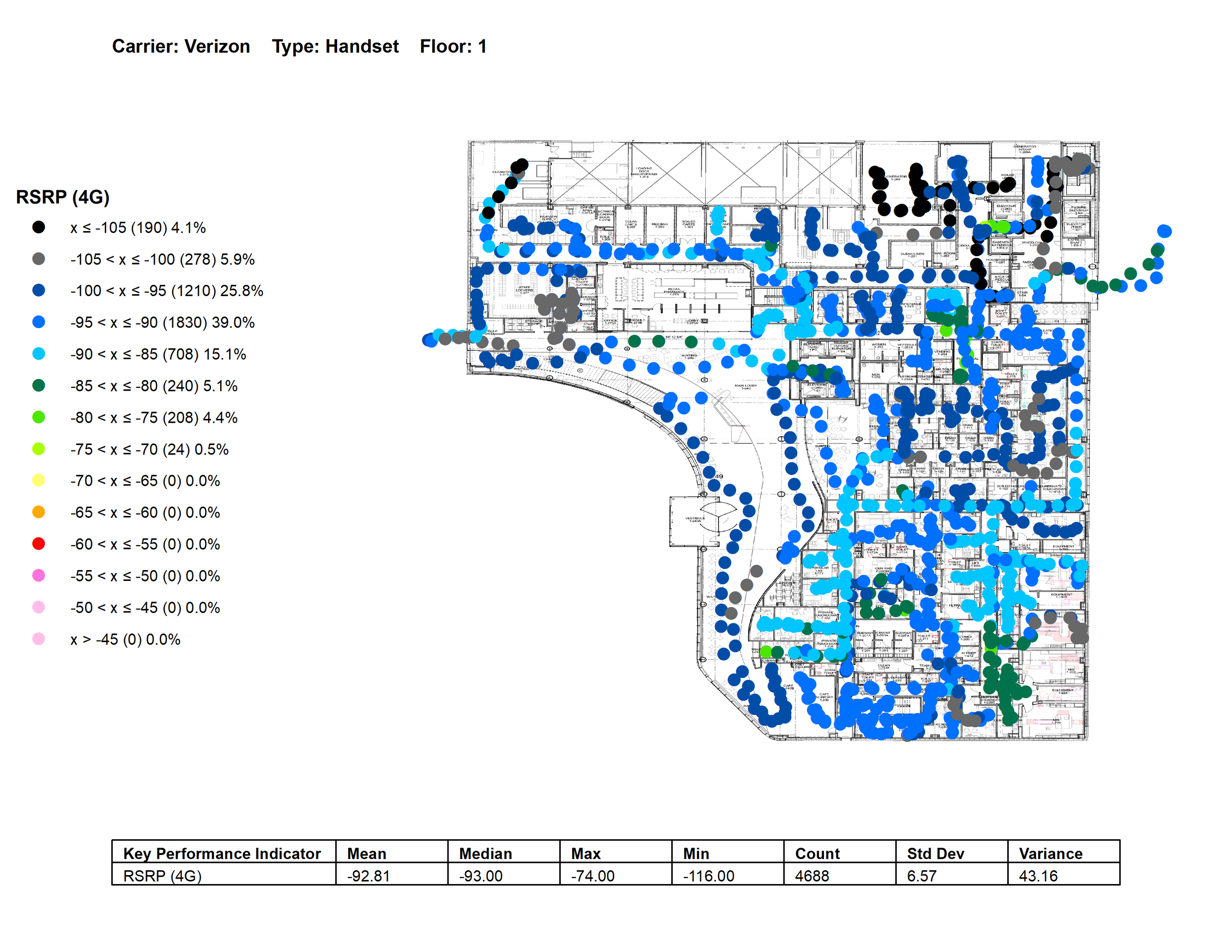
The tests included measuring signal strength, upload and download speed as well as call tests.  The data was delivered via IndoorVu Portal, a web based application, that the building owner could share with its tenants and aggregate to deliver insights to a number of different stakeholders.  The data is aggregated into summary charts by floor as well as displayed in maps as seen below.  

Screen Shot 2020-07-24 at 9.33.53 AM.png
Verizon 4G Signal Strength Example

Verizon 4G Signal Strength Example

Verizon Upload Speed Example

Verizon Upload Speed Example

Result:

The ability for IndoorVu to accurately test cellular networks in all rooms of the building, not just the main hallways or a small number of sample locations, proved incredibly valuable for the Owner.  As a result, they were able to pinpoint and display the performance of all 4 cellular carriers across their entire building.  The data gave them comprehensive and defendable datasets to share with their tenants and stakeholders.  It also gave them the ability to work with their tenants to craft a business plan to improve the network performance with the carriers that served the building.  

Additionally, the building now had a complete digital twin of their building that there leverage to support improvements across a number of other building operations (ie: space planning, asset management and security). 

Post Covid Building Data as a Foundation

The impact of Covid19 and the Coronavirus to our shared Economy has been significant and will undoubtedly change the landscape of our we interact with real estate, our environment and each other for years to come.  

What we know for certain is that the importance of having accurate digital data about your building(s), that is remotely accessible, is critical to the decisions making process regarding how to bring them back online.  

IndoorVu has a unique capability to power many of the systems that will make our global real estate assets safe and secure in this post-Covid19 environment.  Our Image based approach makes it easy to remotely create digital information about all kinds of assets and details inside and around a building.  Whether you are implementing contract tracing solutions, indoor positioning, new space navigation plans or redesigning spaces.  The image data IndoorVu produces, is the critical foundation for those solutions.  

Reach out to learn more about how IndoorVu’s Imagery and data management solutions are helping all kinds of real estate professionals get their buildings back online quickly, safely and efficiently. 

Business Case: In-Building Cellular Design

Problem:

A large, mixed use building wanted to improve the cellular network performance in their building.  They hired a cellular engineering company to design the new network(s), but they did not have usable floor plans, or a baseline analysis of current cellular performance.  The engineering company needed current plans, information about wall materials, as well as a complete cellular network analysis in order to effectively design a solution.  

Summary:

IndoorVu was able to simultaneously collect data for both the Cellular network and building model requirements. The deliverables included measurements from all 4 main US carriers, 360 imagery and custom floor plans designed to integrate into the network design tools used by the engineering company.  IndoorVu also provided updated floor plans and imagery to the building owner for use in their existing Facilities Management and Space Planning tools.    

Screen Shot 2020-06-30 at 5.00.35 PM.png
signal_strength.jpg

Result:

The Engineering company was provided with three main datasets that saved them time and money during the design and construction process.  1) comprehensive data on the existing cellular network conditions needed to design a new optimal indoor network. 2) accurate and formatted floor plan data that could import directly into their design software, saving them significant time modeling it themselves. 3) 360 degree imagery for all parts of the building, both tenant space as well as technical closets and storage areas, saving them a number of site visits and allowing them to make an accurate construction plan remotely.  

The building owner benefited as well, with getting updated floor plans and imagery they used for other operational projects (ie: fire system upgrades, space planning and security enhancements).  

The time to deliver, completeness and flexibility of data provided by IndoorVu provided direct value and cost savings to the cellular network project, and indirect benefit and operational efficiency to the building owner. 

Business Case: Subway Mapping & Routing

Problem:

A transit authority was interested in standing up a routing solution for their subway system.  The system needed to route a user from the street to the train door.  They had stations that ranged in sizes and condition, all which they had very little documentation about.  They needed a solution that could solve the data collection and production challenge for their routing use case, as well as provide critical data to their maintenance and public safety departments.  They wanted accurate 2D plans that were geospatial and could connect into their street level data, as well as 3D asset data and 360 Imagery.     

Summary:

IndoorVu was able to rapidly collect data in all the stations.  The IndoorVu collection system allows maximum flexibility in variable indoor conditions.  After a single scan, IndoorVu was able to create geo-reference 2D plans and network routing data for the routing application that included multiple user types (ie: ADA, Non-ADA, Private, etc.).  It was also able to stand up 360 imagery and map data via IndoorVu Portal that was accessible for other use cases.  The data also integrated directly into the Transit Authority’s existing business systems: GIS, Work Order Management, Asset Management, Facilities Management and Capital Planning. 

IV Portal.  2D Floor Plans by level and 360 imagery

IV Portal. 2D Floor Plans by level and 360 imagery

Result:

The Transit Authority was able to procure all their data needs (collection, production, hosting and integration) from a single vendor.  They received consistent data across all their stations and seamlessly integrated the data into their existing systems.  They were quickly able to stand up a geo-referenced set of underground maps for all their stations that aligned and integrated with their street level data.

Business Case: Home to Product Routing for Retail

Problem:

A retailer wanted to deliver a routing solution to its customers that would let enable ‘Home to Product’ directions.  They had store locations all over the country and needed a scalable solution that could integrate into their existing customer engagement platforms.  

Summary:

IndoorVu was able to rapidly collect data in every store to stand up a baseline of geospatial building information that included floor plans, product locations, other points of interest (bathrooms, customer service, etc.), 360 imagery and routing networks for multiple user types (disabled, private spaces, etc.).  The data was then integrated into a routing engine and delivered via a web and mobile experience to users.

Screen Shot 2020-06-26 at 5.28.15 PM.png
Screen Shot 2020-06-26 at 5.28.32 PM.png

Result:

The retailer was quickly able to validate their store models, update their facilities and asset management systems, and quickly enable a unique routing solution to support their customers, suppliers, maintenance staff.   Beyond improving the consumer experience, this solution reduced the amount of trips that their suppliers, maintenance staff and administration needed to make to each site.

Business Case: Design and Construction Planning for Industrial

Problem:

A Industrial tenant leased an empty warehouse for their operations and needed digital models developed quickly to support their design and construction plans.  They operate warehouses all over the world and were looking for a solution to produce standardized data anywhere in the world.   

Summary:

IndoorVu was able to rapidly collect data in the warehouse with their camera.  Collection is fast (done in a matter of hours) with very little impact to the site.  From the Intelligent Imagery, IndoorVu created accurate geo-referenced 3D models, with annotated key points of interest (e.g. bathrooms, MEP assets, etc.) and delivered 360 degree imagery of all the spaces.  The data was provided as a Revit model and a geodatabase inside of IndoorVu’s web Portal. 

Screen Shot 2020-06-26 at 4.58.14 PM.png
Screen Shot 2020-06-26 at 4.58.00 PM.png
Screen Shot 2020-06-24 at 12.09.26 PM.png

Result:

The building owner went from having little to no data about the building to having a full 3D model, visual 360 imagery and the ability to extract further detail throughout their design and construction process (column heights and tilt, concrete pad details, asset 3D locations, etc.). This allowed them to not only produce value for the design and construction teams, but also provided critical information to their Asset Management, Automation and Innovation teams without having to revisit the site. They also had confidence that the IndoorVu camera system could be quickly deployed anywhere in the world and capable of producing the standardized data for all their warehouse design/construction needs.  

Business Case: Critical Infrastructure and Public Safety

Problem:

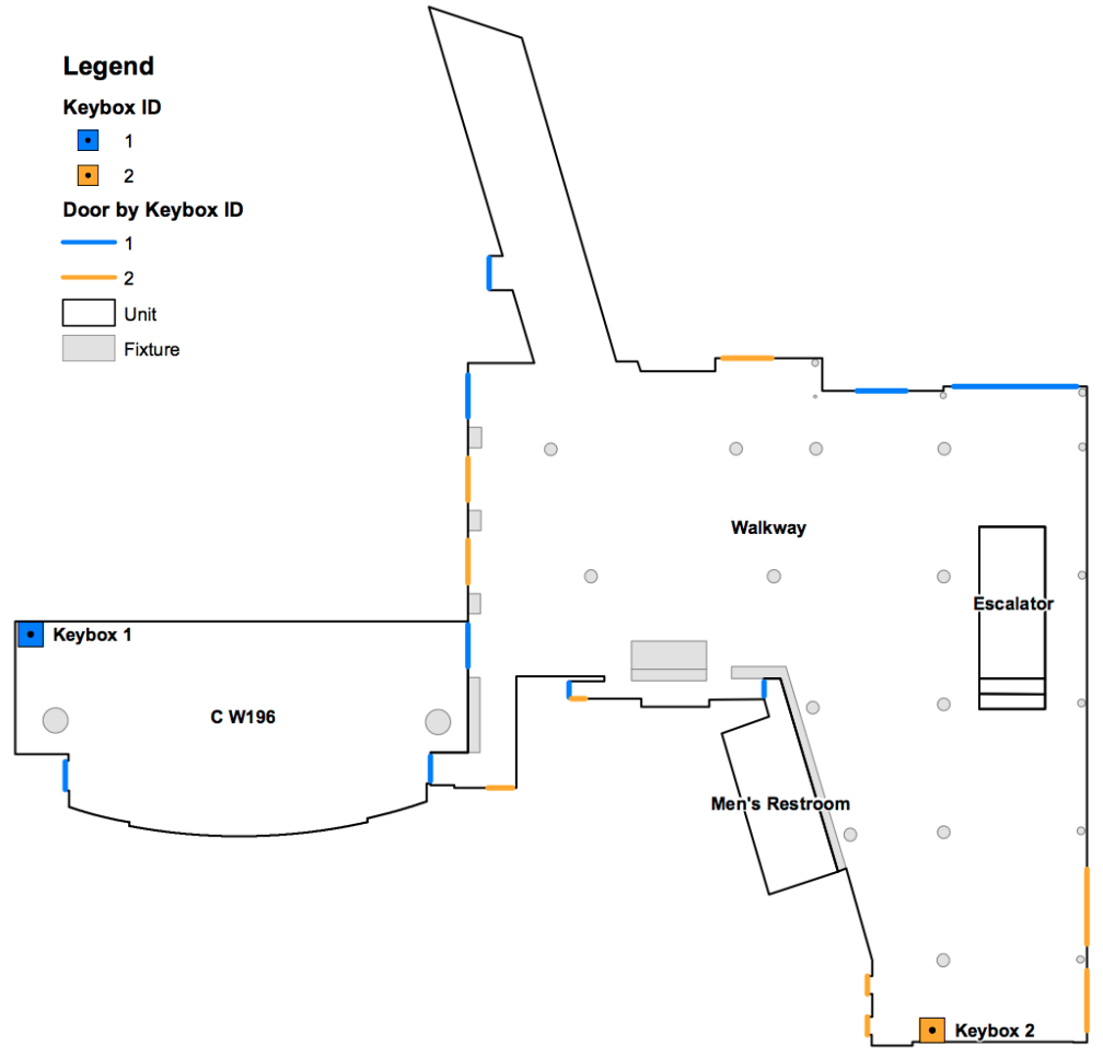
A large convention center needed to provide current building data to security teams for large conferences, political events and public gatherings.  The building data that was required were a current floor plan (in a single file for the entire venue) which included all security elements (fire systems, key boxes, door types (and where the keys to unlock the doors were located), cctv camera locations and access control equipment), communication network performance maps and imagery of the spaces.   The venue was over 5 million square feet and spanned across a number of city blocks.  They building owner had a number of different files that represented floor plans and layouts for different parts of the venue, as there had been many small upgrades done to different parts over time.   

Summary:

IndoorVu deployed a team to the site and within 15 days, collected Intelligent Imagery for all parts of the venue, both public and private spaces.  As part of the collection, IndoorVu integrated a Cellular and Wifi network sensor, so that all the communication networks were measured and mapped simultaneously.  Following collection, IndoorVu rapidly created geo-referenced 2D floor plans and 360 degree imagery.  From the Imagery, IndoorVu could quickly and remotely, extract the 3D position of all security assets.  Communication network data was overlaid onto the maps and all the data was provided via the IndoorVu Portal.  Once the data was delivered it was made available to the internal security teams, as well as configured for delivery to event security teams via IndoorVu Portal access, file download (geodatabase and dwg) and API.

Screen Shot 2020-06-19 at 12.13.42 PM.png
Screen Shot 2020-06-19 at 12.12.41 PM.png

Result:

The convention center quickly went from having very incomplete data about its venue, to having one of the most complete information models of any convention center.  The project was quick and did not impact any of the Convention Centers events or operations.  The accessibility of the data via IndoorVu Portal and through API has made it easy for them to share critical security data with customers planning events of all kinds.  

Business Case: Indoor Routing and Wayfinding in Government/Office

Problem:

County Government has 55 buildings spread across their region.  They want to update their building data, standup an indoor GIS and turn on an indoor routing solution for employees and visitors. They have little to no building models or plans that are digital or accurate.  

Summary:

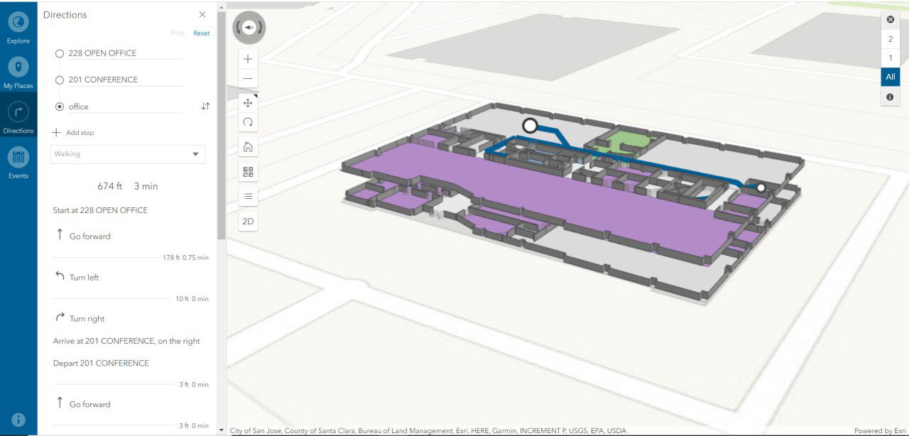
IndoorVu deployed a team to the county and collected Intelligent Imagery for all the country buildings within 14 days.  Then rapidly created geo-referenced floor plans and 360 degree imagery.  That data was delivered via IndoorVu Portal and integrated directly into the County’s existing Esri ArcGIS infrastructure.  IndoorVu also configured the floor plans to import into the Esri ArcGIS Indoors system.  That configuration included modifying the floor plan data model as well as developing a network graph to drive user routing and wayfinding.  

routing.jpg

Result:

The County went from having very little digital data to having a completed digital geospatial system for all their building and assets in a matter of weeks.  They have integrated the floor plans and imagery into their existing GIS database, security, facilities management and maintenance systems.  They saved administrative time and expense by having a single vendor, IndoorVu, create and produce all the data they needed.  They also benefited from having the data seamlessly integrate with their existing systems.  The County now has a foundation for future asset details and digital modeling for all of their properties.  This reduces the amount of travel their staff must to do maintain the assets, as well as allows them to make data available to 3rd party organizations that can benefit from it.  

Business Case: Space Planning in Retail

Problem:

A retail bank company wanted to redesign their branches to optimize their layouts for employee experience and customer satisfaction.  They had hundreds of branch locations, but not all of them had good floor plan data.  They needed a scalable solution that could deploy all over the country and produce consistent results.  They also wanted to have flexibility in the level of detail they could extract on a branch by branch basis.  

Summary:

IndoorVu configured resources to collect data across all branch locations that needed data, approximately 50 sites across a dozen states in the US.  The teams spent just over an hour in each branch, hardley impacting the operations of the branch.  The Intelligent Imagery that was collected and produced enabled IndoorVu to quickly create complete 2D geo-referenced floor plans for all the buildings, plus 360 imagery to provide context and additional visual detail.  

IV Portal: Floor Plans, 360 Imagery

IV Portal: Floor Plans, 360 Imagery

Result:

The Bank’s space planning team was able to create a standardized process for assessing and redesigning their spaces.  The IndoorVu Portal was a single web-accessed application that the Bank’s teams could remotely access.  They were able to make rapid, educated decisions about the spaces and the level of effort to achieve the new designs. The Bank also now has a foundation for detailed 3 Dimensional mapping and modeling for future improvements and changes to the branches as they need. 

Business Case: Due Diligence in Commercial Office

Problem:

Large Commercial REIT was in the process of doing diligence on the acquisition of a 1.5 million square foot office building.  The building had very little documentation about it.  They knew that it had been primarily a single tenant space since its construction, but they had a plan to make it a multi-tenant building.  They needed to know details on the size of the spaces, current condition of the floors and rooms and an accurate building model so they could properly forecast revenues, develop a construction plan/budget for redesign and negotiate final purchase price.  They were under a time constraint as they needed to finalize the purchase quickly.   

Summary:

IndoorVu deployed to the site and collected Intelligent Imagery for the entire building in less than 3 days.  Collection happened primarily in the evenings so current tenants were not impacted.  Within 6 weeks, IndoorVu delivered detailed 2D floor plans of the entire building, a 2017 BOMA (commercial office) space analysis and 360 degree imagery for all spaces in the building.

IV Portal:  all levels, Floor Plans, BOMA Analysis and 360 Degree Imagery

IV Portal: all levels, Floor Plans, BOMA Analysis and 360 Degree Imagery

Result:

Because the data was collected and delivered so quickly, the REIT was able to negotiate a more favorable purchase price.  Because they could access all parts of the building virtually (through maps and imagery) they were able to reduce staff travel, save schedule time and reduce costs to start the construction phase. They were also able to share the virtual building data with their architects, contractors and technology platforms involved in the redesign of the space, further reducing the cost and schedule of the actual redesign and construction process.

Business Case: Asset Inventory in Retail / Industrial

Problem:

A large retail occupier needed to update and improve their asset management system.  They had basic floor plans for all their sites, but lacked detail about the assets within them (ie: fire systems, hvac, lighting, electrical, plumbing, utilities).  They needed a scalable solution that could work across hundreds of sites and produce consistent data.  They also wanted to remove a number of manual steps from their current process both in collecting asset data as well as importing it into their current Enterprise Asset Management (EAM) system.   

Summary:

IndoorVu configured resources to collect data across hundreds of sites and multiple geographies.  IndoorVu teams spend less than a day in sites that are hundreds of thousands of square feet.  Then remotely can extract the precise 3 Dimensional information for all kinds of assets.  When the asset data is extracted from the imagery, it populates a pre-configured data model that matches the customers EAM system.  IndoorVu delivers all the data via the IndoorVu Portal, which visualizes all the assets, places them into the correct location on the floor plan and provides an editable interface to update and/or modify asset attributes. 

IV Portal.  Floor Plans, Asset Details, 360 Imagery

IV Portal. Floor Plans, Asset Details, 360 Imagery

Result:

The net result is that instead of taking months of expert’s time to visit each site and manually collect data in the field then again manually import that data into an EAM, the expert can now remotely access imagery for each site and extract the location and details of assets. The work gets done much faster and with less costs.  The retailer also has comprehensive imagery for all their sites and the ability to extract additional 3 Dimensional information about their buildings on an as needed basis.  

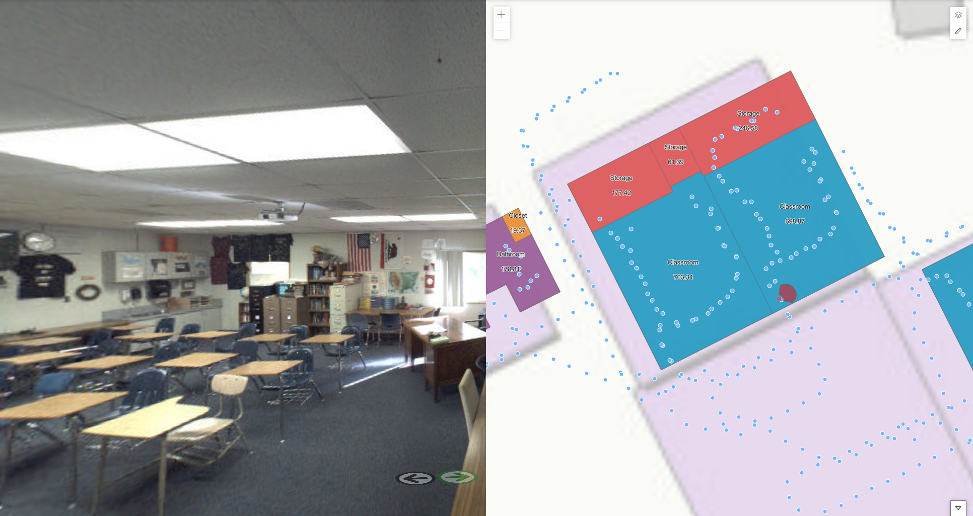
Business Case: Space Planning and Design in Education

Problem:

This school district was faced with the challenge of redesign their spaces to comply with new Covid-19 restrictions for student spaces.  Their challenge was that they had paper drawings for all their buildings.  They needed to update the drawings, ensure they were correct and scaled, integrate them into GIS tools to optimize the space layouts and enable virtual teams to collaborate on redesigning the spaces.   = 

Summary:

IndoorVu was rapidly collected data at 5 High Schools throughout the district.  From the IndoorVu Intelligent Imagery, geospatial floor plans were generated and enhanced with 360 degree imagery.  The data was loaded into the IndoorVu Portal, provided as CAD (dwg) files and as GIS (geodatabase) files.  

IndoorVu Portal.  2D Floor Plans, 360 Imagery

IndoorVu Portal. 2D Floor Plans, 360 Imagery

Result:

The School District was able to quickly stand up data and a standard workflow across all their High Schools to remotely reconfigure the spaces.  They were able to seamlessly integrate their data into their existing GIS and CAD software tools.  The 360 Imagery provided critical visual information about their spaces so that teams working from home could be effective.  

Business Case: Renovation and Design in Hospitality / Residential / Retail

Problem:

A real estate developer purchased an old motel building with a plan to renovate it into a mixed use property with retail and apartments.  The 130,000 sqft building had very little documentation available and was on the east coast, not close in proximity to the Family Office or their Architects. They needed digital building data to redesign the building, plus in a Covid-19 environment, they needed a way to share information with each other and eventual contractors/vendors without requiring travel to the site.    

Summary:

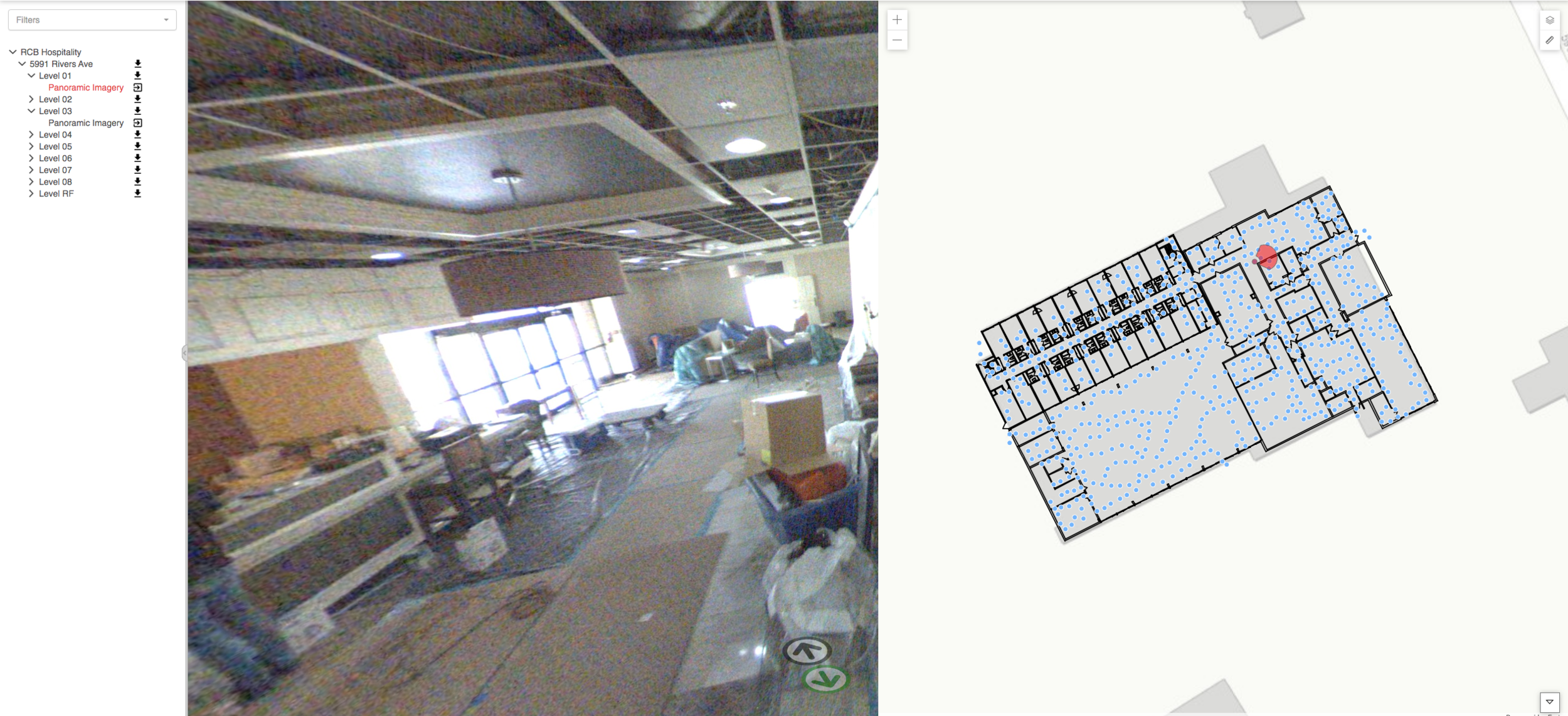
IndoorVu deployed a team to the property for 1.5 days to collect data.  From the Intelligent Imagery, IndoorVu was able to iteratively produce digital building data to support the Architects work.  The ultimate deliverable was a comprehensive, 300 level BIM model for all visual assets of the building, including structural and MEP elements above the ACT ceilings and on the 3 roof levels.  The models were broken down into 2D maps, combined with 360 imagery and delivered via IndoorVu Portal.  

IV Portal. 2D floor plans and 360 Imagery

IV Portal. 2D floor plans and 360 Imagery

1st Floor Detailed 2D Plans

1st Floor Detailed 2D Plans

LOD 300 3D Site and Building Model

LOD 300 3D Site and Building Model

Result:

Access to the data via IndoorVu Portal was provided to engineers, contractors and other stakeholders to access remotely and reduce the travel required and the number of people needing to enter the building.  The Architects were able to develop detailed design, demolition and capital plans without having to travel to the site, saving time and cost.  The owners were also able to use the plans and imagery to support early leasing efforts for the space before the construction was complete.

Business Case: Advanced Building Documentation in Retail

Problem:

Large Retailer acquired 34 new brick and mortar locations.  The new locations were spread all across the east coast of the US and they had little to no documentation about the condition, layout, etc. of the buildings.  They needed to understand what they had bought, how to redesign the spaces and the level of effort that was going to be required to do so.   

Summary:

IndoorVu deployed to the sites of the newly acquired buildings and within 14 days had collected Intelligent Imagery for all the stores, in a total of over 2.4 million square feet across 5 different states.  Within 2 months from the data collection effort, IndoorVu created complete 3D models of all the buildings which included site plans, full ceiling plans, walk path details and 360-degree imagery of every space in every building.  The data was all organized by building, floor and room and delivered via IV Cloud and IV Portal.

Screen Shot 2020-06-10 at 3.51.02 PM.png
IV Portal.  2D Floor Plan, Ceiling Plans, 360 Imagery

IV Portal. 2D Floor Plan, Ceiling Plans, 360 Imagery

Result:

The retailer was able to share this new building data with all stakeholders in their redesign and construction process via a simple web application.  Beyond just having floor and ceiling plans, the 360 Imagery enabled designers, store planners, and store managers to better understand and collaborate throughout the entire process of updating these newly acquired sites.  IndoorVu saved the retailer time, money and significant iterations on design and development.