Routing

Post Covid Building Data as a Foundation

The impact of Covid19 and the Coronavirus to our shared Economy has been significant and will undoubtedly change the landscape of our we interact with real estate, our environment and each other for years to come.  

What we know for certain is that the importance of having accurate digital data about your building(s), that is remotely accessible, is critical to the decisions making process regarding how to bring them back online.  

IndoorVu has a unique capability to power many of the systems that will make our global real estate assets safe and secure in this post-Covid19 environment.  Our Image based approach makes it easy to remotely create digital information about all kinds of assets and details inside and around a building.  Whether you are implementing contract tracing solutions, indoor positioning, new space navigation plans or redesigning spaces.  The image data IndoorVu produces, is the critical foundation for those solutions.  

Reach out to learn more about how IndoorVu’s Imagery and data management solutions are helping all kinds of real estate professionals get their buildings back online quickly, safely and efficiently. 

Business Case: Subway Mapping & Routing

Problem:

A transit authority was interested in standing up a routing solution for their subway system.  The system needed to route a user from the street to the train door.  They had stations that ranged in sizes and condition, all which they had very little documentation about.  They needed a solution that could solve the data collection and production challenge for their routing use case, as well as provide critical data to their maintenance and public safety departments.  They wanted accurate 2D plans that were geospatial and could connect into their street level data, as well as 3D asset data and 360 Imagery.     

Summary:

IndoorVu was able to rapidly collect data in all the stations.  The IndoorVu collection system allows maximum flexibility in variable indoor conditions.  After a single scan, IndoorVu was able to create geo-reference 2D plans and network routing data for the routing application that included multiple user types (ie: ADA, Non-ADA, Private, etc.).  It was also able to stand up 360 imagery and map data via IndoorVu Portal that was accessible for other use cases.  The data also integrated directly into the Transit Authority’s existing business systems: GIS, Work Order Management, Asset Management, Facilities Management and Capital Planning. 

IV Portal.  2D Floor Plans by level and 360 imagery

IV Portal. 2D Floor Plans by level and 360 imagery

Result:

The Transit Authority was able to procure all their data needs (collection, production, hosting and integration) from a single vendor.  They received consistent data across all their stations and seamlessly integrated the data into their existing systems.  They were quickly able to stand up a geo-referenced set of underground maps for all their stations that aligned and integrated with their street level data.

Business Case: Indoor Routing and Wayfinding in Government/Office

Problem:

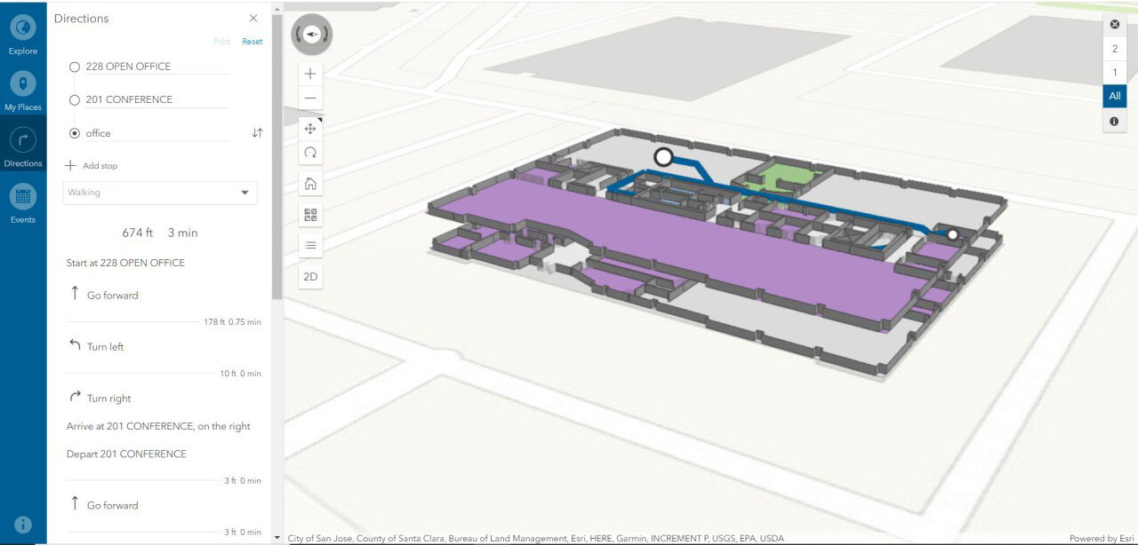
County Government has 55 buildings spread across their region.  They want to update their building data, standup an indoor GIS and turn on an indoor routing solution for employees and visitors. They have little to no building models or plans that are digital or accurate.  

Summary:

IndoorVu deployed a team to the county and collected Intelligent Imagery for all the country buildings within 14 days.  Then rapidly created geo-referenced floor plans and 360 degree imagery.  That data was delivered via IndoorVu Portal and integrated directly into the County’s existing Esri ArcGIS infrastructure.  IndoorVu also configured the floor plans to import into the Esri ArcGIS Indoors system.  That configuration included modifying the floor plan data model as well as developing a network graph to drive user routing and wayfinding.  

routing.jpg

Result:

The County went from having very little digital data to having a completed digital geospatial system for all their building and assets in a matter of weeks.  They have integrated the floor plans and imagery into their existing GIS database, security, facilities management and maintenance systems.  They saved administrative time and expense by having a single vendor, IndoorVu, create and produce all the data they needed.  They also benefited from having the data seamlessly integrate with their existing systems.  The County now has a foundation for future asset details and digital modeling for all of their properties.  This reduces the amount of travel their staff must to do maintain the assets, as well as allows them to make data available to 3rd party organizations that can benefit from it.